Understanding terrestrial and aquatic ecosystem processes in the Congo Basin (DRC)
An insight into the SAE group's DRC activities was published in the Science & Technology journal from the PanEuropeanNetwork in December 2016. The whole article can be viewed Download here (PDF, 972 KB) and more recently in 2020 in the Open Access Government.
Forest Greenhouse Gas Emissions
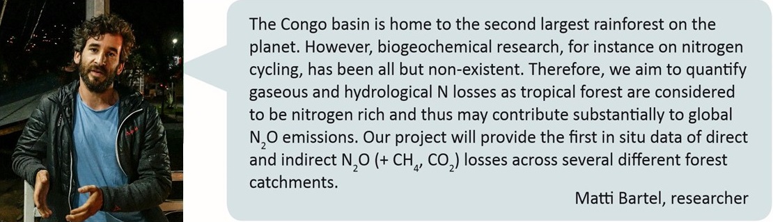
It is crucial to monitor greenhouse gas exchange between land and atmosphere, especially in currently understudied but yet important ecosystems globally. This drastically pertains to the African continent. While there is a dense network of long-term observatory sites for greenhouse gas fluxes in industrialized countries, observations on the African continent are sparse due to a multitude of reasons including poor infrastructure and limited scientific capacity. So far, there are only fifteen CO2 flux sites running across the entire African continent compared to 550+ globally. In addition, only a handful of studies exist which include in situ N2O and CH4 flux measurements from African tropical forests despite these ecosystems being the second most important source of N2O emissions and a strong sink for CH4.
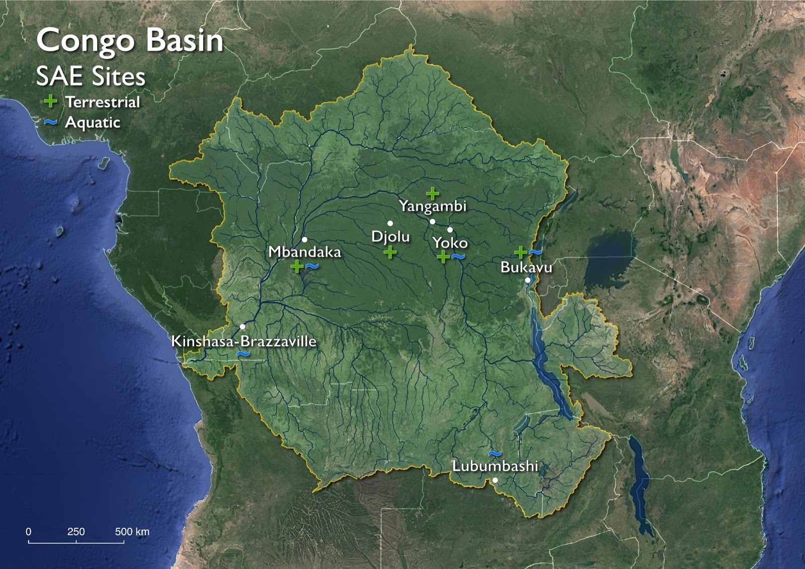
For the above mentioned reasons, the Sustainable Agroecosystems lab has established several soil greenhouse gas observation sites in the DRC as a joint effort between the University of Ghent (Belgium) and several institutions in the DRC including the Catholic University of Bukavu, University of Kisangani and the Botanical Garden of Eala, Mbandaka. These long term monitoring activities are complemented by several shorter measurement campaigns at various other forest sites in the Congo basin (see map). Accompanying shorter measurement campaigns aim at a spatial characterization of greenhouse gas exchange and at a mechanistic understanding of underlying processes using state of the art isotope techniques.
Aquatic Fluxes of Carbon and Nutrients
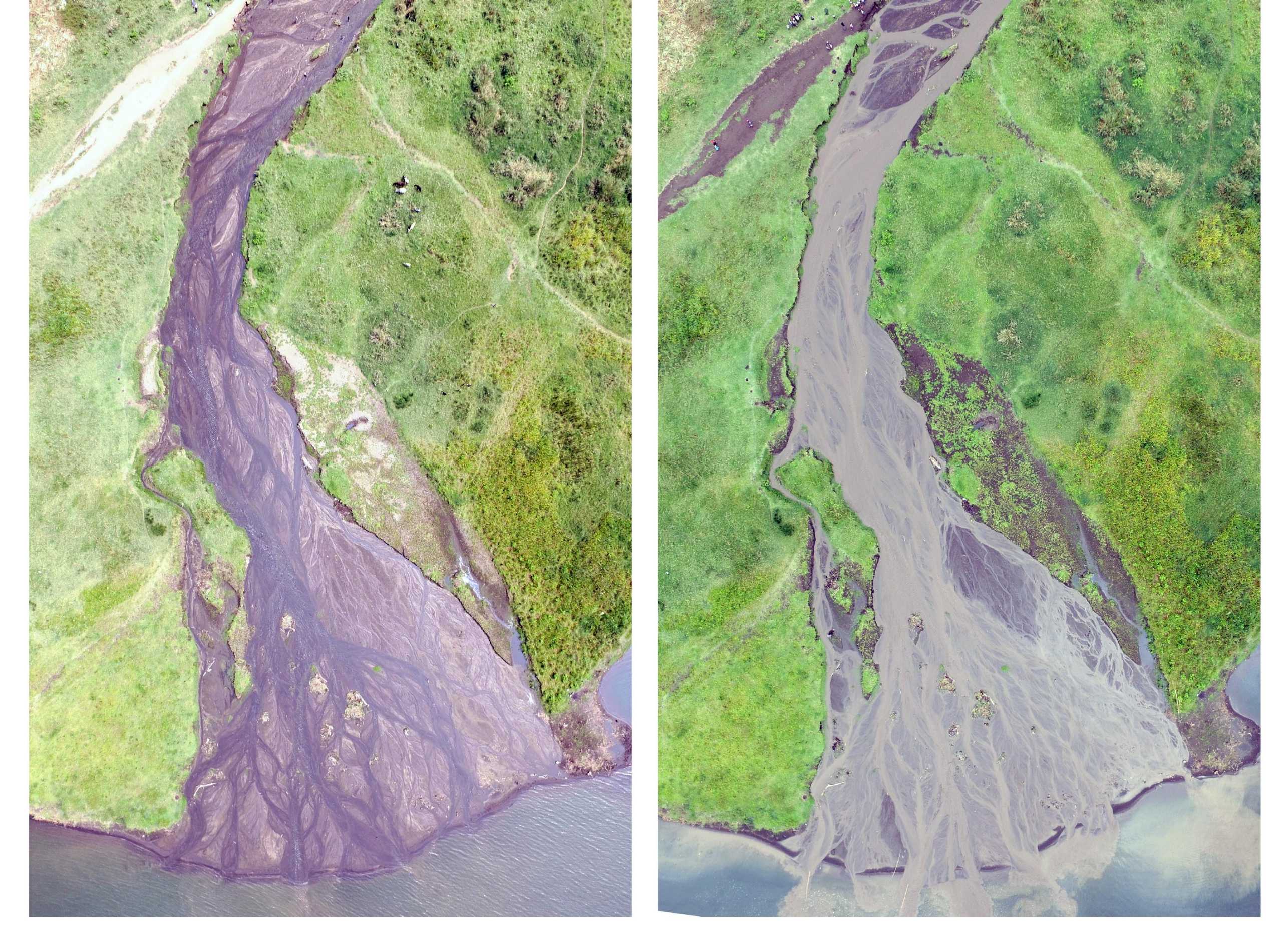
In addition to exchanging greenhouse gases with the atmosphere, tropical forests export significant quantities of C and nutrients to aquatic ecosystems such as rivers and lakes. Although rarely considered in terrestrial budgets, this lateral loss can represent an important component of landscape biogeochemical cycles. For example, in the case of C, failure to account for aquatic losses can bias estimations of Net Ecosystem Production by 4-60%.
The SAE Group has established a network of river and stream monitoring sites throughout the Congo Basin to monitor the natural fluxes and fates of dissolved and particulate C, N, and P. This work is conducted as a collaborative effort with the FORSEDCO project housed at UC Louvain, Belgium. As an extension to this work, the SAE group has set up a paired watershed study to assess how deforestation and land-use conversion to agriculture affects the export and fate of C, N, and P from the Congo’s lowland forests.
More information on these projects is available from the external page Congo Biogeochemical Observatory website.
Aims
Specifically, the aims of the group are to:
- Conduct exploratory manual chamber-based measurement campaigns to characterise CO2, CH4 and N2O emissions from various forest sites in the Congo Basin;
- Establish long-term observation of CO2, CH4 and N2O fluxes from tropical rainforests in the Congo Basin using micrometeorological techniques;
- Gain a mechanistic understanding of N2O emissions using state-of-the-art isotope analysis to partition source processes;
- Estimate the effect of land-use change from natural to agricultural ecosystems on the cycling of C and N; and
- Assess how forest conversion to agriculture might augment the flow of C from terrestrial to aquatic ecosystems.
Country: Democratic Republic of Congo
System: Primary tropical rainforest
Project duration: 2016-2022
Project partner: ETH Zurich (Switzerland); Ghent University (Belgium); Université Catholique de Bukavu (DR Congo); Observatoire Volcanologique de Goma (DR Congo); IITA - International Institute of Tropical Agriculture (Kenya); Université Catholique de Louvain (Belgium); Université Officielle de Bukavu (DR Congo)
Project funding: ETH Zurich foundation, SNF international short visits

For further information please contact Matti Barthel or Johan Six or Travis Drake.